
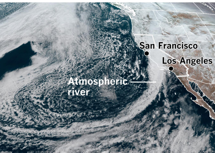
California is on high alert as meteorologists forecast an impending major atmospheric river event that promises to bring significant rainfall across the state. This weather pattern shift is anticipated to have profound effects, especially in Southern California, which is set to experience conditions distinct from the usual climate patterns. The state, already witnessing 3 to 5 inches of rain in areas like San Diego and Chula Vista, is preparing for an even more intense downpour that could exacerbate the current situation.
Impending Storms Amplify Concerns
The recent heavy rains in regions like San Diego are just a prelude to what’s expected to be a more dramatic change in weather patterns. Meteorologists are closely monitoring the development of several storms poised to hit the state, doubling down on the already saturated conditions. The aftermath of a major winter storm has left little time for recovery, and the forecast of additional storms next week adds to the concern. The unusual weather event in San Diego, although seemingly unrelated to the larger pattern shift, serves as a critical indicator of what might be on the horizon.
With El Niño winters historically bringing wetter conditions to California, the expected pattern change could signal the start of an unusually wet February. The focus of rainfall is initially on the Pacific Northwest, but trends indicate a southward shift that could bring substantial precipitation to Northern California and possibly extend to Southern California, including major cities like Los Angeles and San Diego.
Weather offices are highlighting a pattern shift that could bring about significant changes, with uncertainties remaining about the exact timing and amounts of rainfall. However, the jet stream’s extension is a clear sign that the coastline is poised for a deluge, raising concerns about potential flooding. The influence of El Niño could exacerbate the situation, leading to an active week ahead not only for California but also for the southern United States, with the Southwest potentially facing flooding risks.
Meteorologists emphasize the need for preparedness, noting that the entire 840-mile stretch of California’s coastline could be at risk of flooding. The Climate Prediction Center has indicated high probabilities of above-average precipitation, which is significant given that this period marks the state’s wet season. The first week of February is expected to be particularly stormy, with a high likelihood of continued above-average rainfall.
The anticipated weather pattern, while warmer, might limit snow accumulation in the Sierra mountains, an aspect critical for the state’s water supply. Nonetheless, some snowfall is still expected, which could aid in the recovery efforts in regions like San Diego. The calm before the storm, characterized by sunny skies and quiet conditions, will provide a brief respite before the atmospheric river brings its full impact to bear on the state.
Read More:
- Michigan Announces $550 Tax Rebate Checks for 700,000 Families in 2024 Amid Inflation Challenges
- Beaver dam blamed for huge chunk of road that washed away during rainfall in Livingston neighborhood
- Attorney General Ken Paxton Seeks Protective Order Amidst Ongoing Whistleblower Suit
As California braces for this major atmospheric event, the emphasis is on preparedness and resilience. The upcoming weather patterns underscore the unpredictable nature of climate systems and the need for vigilance in the face of potential natural disasters. With the state gearing up for what could be a defining weather event of the season, the focus is on safeguarding communities, managing flood risks, and ensuring a swift recovery from the anticipated deluge.